Insights
J.S. Held Acquires Shechter & Everett to Expand Forensic Accounting Capabilities for Family Law Disputes in Florida
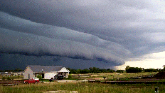
Read MoreWind events are generally characterized as straight-line winds; however, some are isolated and short-lived, while others are not. But what’s the difference?
The answer often lies within the presentation of the thunderstorm itself. For example, ordinary afternoon thunderstorms can result in isolated, short-lived downbursts, but generally do not affect a wide area. However, elongated thunderstorm complexes driven by rigorous atmospheric dynamics can travel hundreds of miles, resulting in a wide swath of damaging wind gusts.
To understand thunderstorm winds, it is important to understand thunderstorms themselves. Thunderstorms occur in cumulonimbus clouds. Cumulonimbus clouds form due to humid, unstable, rising air. The rising air condenses into a cloud containing liquid water, hail, and ice. The concentration and cohabitation of water and ice within the thunderstorm produces lighting, which differentiates a thunderstorm from a rain shower. However, at some point during the thunderstorm’s lifecycle, it is no longer able to hold the massive weight of its contents suspended in the air.
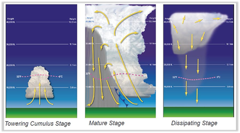
Downbursts are powerful wind events that are caused by downward-moving air from a cumulus-type cloud. [1] [2] These strong downdrafts occur when a thunderstorm (or rain shower) can no longer hold the enormous amount of water weight suspended in the air overhead. This weight plummets out of the sky, gaining momentum as it falls, and displaces the air beneath it. Added features like dry air beneath the storm cloud can result in evaporating some (or all) of this falling precipitation, enhancing the downdraft speed by replacing the evaporated water molecules with heavier nitrogen and oxygen molecules. [3]
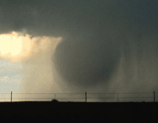

Downbursts can result in powerful straight-line winds—in some cases exceeding those of weak tornadoes. While downbursts are usually wider than tornadoes, they are still narrow in comparison to other thunderstorm wind events. A microburst, by definition, is less than or equal to four kilometers in width. [4]
Downbursts can also produce gust fronts, which travel outward from a storm (sometimes dozens of miles) and can be a hazard to both life and property. Dust storms, for example, often form along gust fronts.

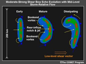
A bow echo is a bowed, bulged (or arched) thunderstorm presentation, sometimes embedded within a larger line of thunderstorms such as squall lines. Bow echoes have a kidney bean (or backward “C”) shape and are typically associated with an axis of enhanced straight-line winds that can translate to damaging wind gusts at the surface which spread horizontally and repeatedly enforce the bowing structure. [5] [6] Simply put, a bow echo is simply a bowed linear thunderstorm event in which the highest winds are often observed.

Bow echoes result in powerful wind gusts due to several factors. Downburst winds are common within bow echoes, and tornadoes can also form within the storm, especially on the northern periphery known as the “bookend vortex." Additionally, in a mature bow echo, strong mid-tropospheric winds (known as the rear-inflow jet) will cascade downward behind the bow echo resulting in the momentum transfer of high winds aloft to the low levels, if not the ground.
A derecho (pronounced “deh-REY-cho”) is a widespread, long-lived windstorm associated with thunderstorm squall lines and quasi-linear convective systems (QLCS). [8] A derecho is a bow echo, but not all bow echoes are derechos. To be classified as a derecho, the following criteria must be met:
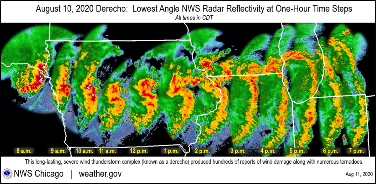
A derecho in Iowa and northern Illinois on August 10, 2020, resulted in $11.5 billion worth of damage, making it the costliest known non-tornadic thunderstorm wind event in modern United States history, [9]falling short of only one other severe thunderstorm event—the April 2011 tornado outbreak in the southeastern U.S. [10] Over one million people lost power, some for weeks. Severe crop damage also occurred.
Derecho events pose a significant challenge to forecasting, as the atmospheric variables required for a derecho to occur often have a rapidly changing domino-effect pattern. Thus, it is important to routinely check the weather forecast, especially during storm season.
Thunderstorm wind events are diverse and complex. Some thunderstorms produce several different types of wind events within their lifecycle and can merge with nearby thunderstorms to form an even larger storm complex capable of widespread extreme winds, such as a derecho. While not discussed within this article, tornadoes can also form in thunderstorms, resulting in additional wind-related damage and safety concerns.

Winds are not only associated with thunderstorms, such as high winds during tropical storms and hurricanes, although even these events often exhibit both downbursts and tornadoes. Furthermore, high winds can also accompany strong cold fronts which sweep across a continent, they can be subjected to mountain down-sloping effects (such as Chinook winds and Santa Ana winds), and even appear in the form of hazardous dust devils on hot, sunny afternoons in desert climates.
Know Your Thunderstorm Risks with Expert Forensic Meteorologists
American Meteorological Society Certified Consulting Meteorologists (CCMs) can assist global clients in understanding their weather risks, gaining a clear picture of the weather event following a loss, and mitigating future losses.
We would like to thank Daniel Schreiber, CCM & Kaj O’Mara, CBM, CCM for providing insight and expertise that greatly assisted this research.
Dan Schreiber is a Vice President in J.S. Held's Forensic Meteorology service line. He is a Certified Consulting Meteorologist with over 10 years of experience in military, aviation, and severe weather operations. Mr. Schreiber has provided consulting and expert services for both plaintiff and defense law firms, as well as insurance adjusters, appraisers, umpires, and policyholders throughout North America. He has been consulted and/or retained as an expert in over 700 matters and has testified in both depositions and during trials in state and federal courts. He regularly plays an integral role in multi-million-dollar insurance disputes and injury/wrongful death lawsuits from coast to coast. Before joining J.S. Held, Dan was a highly successful meteorology business owner.
Dan can be reached at [email protected] or +1 830 453-0255.
Kaj O’Mara is a Senior Meteorology Consultant in J.S. Held's Forensic Meteorology service line. He is a Certified Consulting Meteorologist (CCM) with over 16 years of experience in operational meteorology. An elite communicator with dual meteorology certifications, Mr. O’Mara brought his expertise in severe weather to over one million residents across eastern Iowa during his tenure as an Emmy Award-winning Certified Broadcast Meteorologist (CBM). Throughout his tenure in the broadcast industry, Mr. O’Mara’s expertise in a wide range of hazardous and impactful weather were widely utilized by the agricultural and transportation industries, as well as revered by numerous school districts, college campuses, and sports teams. Mr. O’Mara routinely employed his role as a National Weather Service Weather Ready Nation Ambassador across numerous municipalities, school districts, and emergency management sectors.
Kaj can be reached at [email protected] or +1 319 250 7797.
[1] https://glossary.ametsoc.org/wiki/Downburst
[2] https://glossary.ametsoc.org/wiki/Downdraft
[3] https://www.weather.gov/lmk/downburst
[4] https://glossary.ametsoc.org/wiki/Microburst
[5] https://www.noaa.gov/jetstream/derechos/bow-echoes
[6] https://glossary.ametsoc.org/wiki/Bow_echo
[7] https://glossary.ametsoc.org/wiki/Rear-inflow_jet
[8] https://www.spc.noaa.gov/misc/AbtDerechos/derechofacts.htm
[9] https://www.weather.gov/lot/2020aug10
[10] NOAA National Centers for Environmental Information (NCEI) U.S. Billion-Dollar Weather and Climate Disasters (2023). https://www.ncei.noaa.gov/access/billions/, DOI: 10.25921/stkw-7w73
Consulting with a professional meteorologist regarding reported (or conversely, unreported) storm events is fundamentally crucial to understanding a storm’s occurrence (or lack thereof) for insurance claims. Find out why....
Even in well-seasoned hurricane areas, human factors can lead to significant issues. Learn more about what not to do in a tropical storm....
When performing inspections of buildings or structures after a catastrophic event, such as a hurricane, several types of damage conditions may be encountered. The unpredictability of storms can present many challenges when determining how to...